
 <------ Click here for Current weather (might be a little dark at night)
I'm gonna hike the JMT in August, starting next week, beginning in Yosemite Valley and finishing at Mt. Whitney. Instead of working on meal planning today (I have to ship the resupplies tomorrow), I'm spending time putting my trip plans on the web. Hmmm.
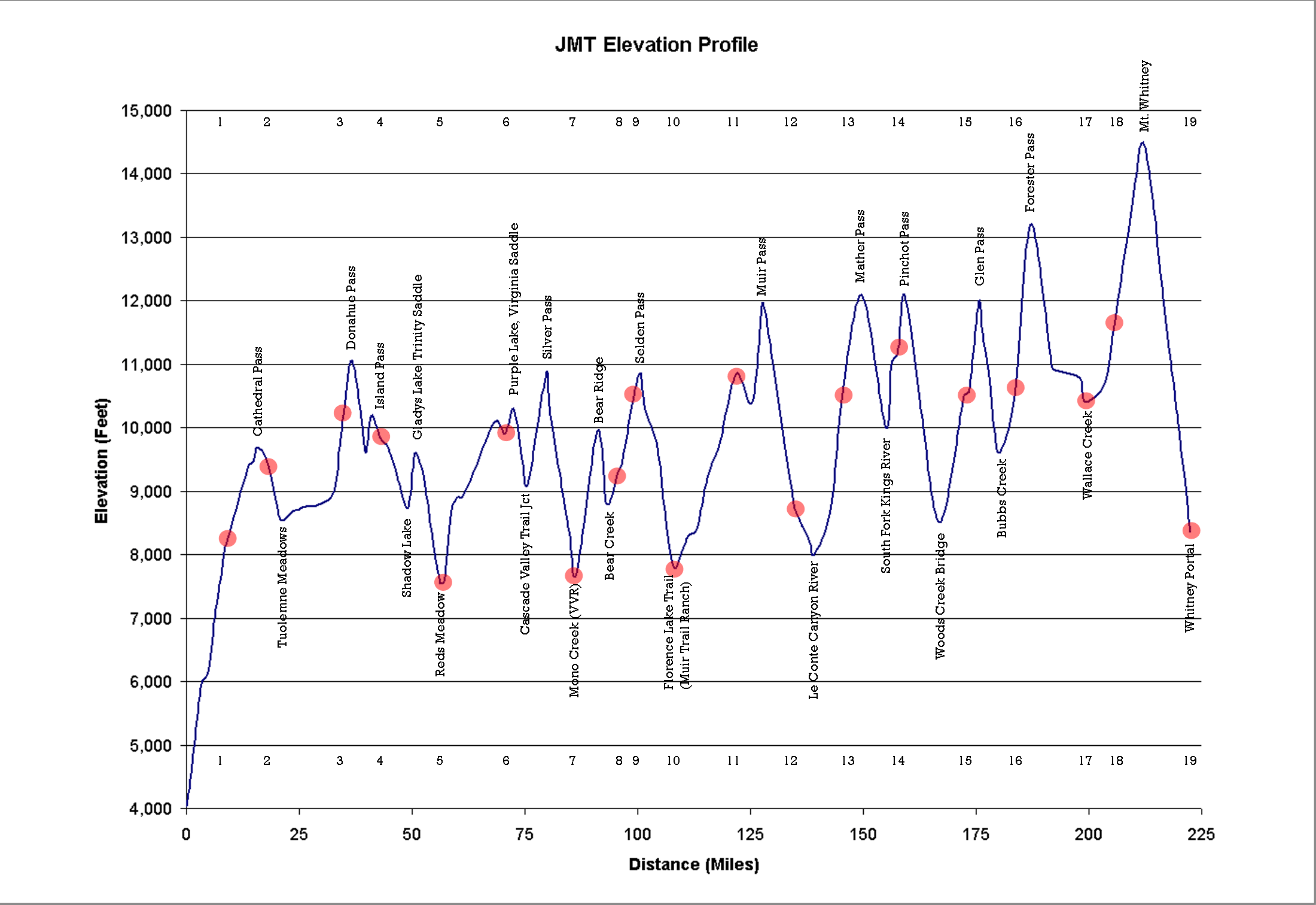
The red dots in the JMT Elevation Profile below will lead you to topo maps that show the relevant section of the trail.
The spreadsheet at the bottom shows mileages and elevations.
I've got my fishing pole, camera, solar charger, a solo tent, a lightweight but warm down jacket for the cool nights, and a great pair of boots. I may even take my backpacking espresso maker. No (practical) way to offer updates along the way, but maybe I'll keep a journal so I can share a story when I get back.
Wish me luck! That is, if you believe is that kind of thing.
<------ Click here for Current weather (might be a little dark at night)
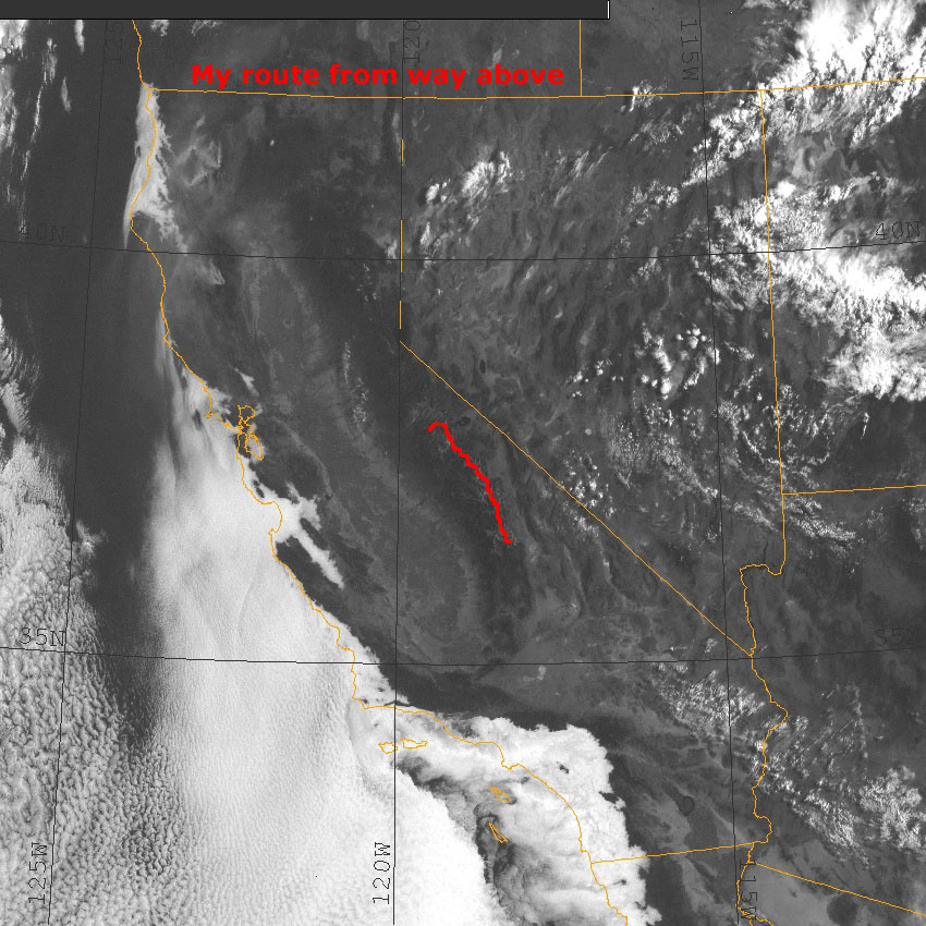
My route superimposed on a non-current weather shot --->>>
Click the map to the left for current weather.
Aug 1: My friend, Eric, the one who introduced me to backpacking and the Sierras 2 years ago, suggested I spend the last night on top of Mt. Whitney. So, that's the new plan. I'm too lazy to change the chart. You can move dot 18 up the mountain using the powers of your mind. The new moon will be night 16, just 2 nights before my Whitney sleepover. The stars should be spectacular from the highest point in the continental U.S.
 Aug
2: Because you can, here's the link to
track my resupply bucket on its separate journey to Muir Trail Ranch.
I need it by day 10 (Aug 16th). You're looking at nearly 20 lbs of
dried everything on the floor, just before I tried (unsuccessfully) to stuff it
all into that 5 gallon paint bucket. Hmmm, clean socks or 2 dinners, socks
or dinner, hmmm. And some of you are wonder this: "He's
struggling to get all that food into a 5 gallon paint bucket. How does he
expect to make it fit into a much smaller bear can? Afterall, doesn't the bear
can have to fit in his backpack?" Good question. Quick arithmetic,
9" diameter, 14" high cylindrical bear can holds 3.86 gallons. I hope I
got that right. So I'll need to give everything a good scrunch, and I
should be able to carry lunch and dinner for the first day after resupply
outside the bear can. And maybe I'll just eat what doesn't fit.
Aug
2: Because you can, here's the link to
track my resupply bucket on its separate journey to Muir Trail Ranch.
I need it by day 10 (Aug 16th). You're looking at nearly 20 lbs of
dried everything on the floor, just before I tried (unsuccessfully) to stuff it
all into that 5 gallon paint bucket. Hmmm, clean socks or 2 dinners, socks
or dinner, hmmm. And some of you are wonder this: "He's
struggling to get all that food into a 5 gallon paint bucket. How does he
expect to make it fit into a much smaller bear can? Afterall, doesn't the bear
can have to fit in his backpack?" Good question. Quick arithmetic,
9" diameter, 14" high cylindrical bear can holds 3.86 gallons. I hope I
got that right. So I'll need to give everything a good scrunch, and I
should be able to carry lunch and dinner for the first day after resupply
outside the bear can. And maybe I'll just eat what doesn't fit.
Muir Trail Ranch's web site makes resupply seem easy. I'll report later about how it turned out.
Aug 3: The USPS has delivered, thru sleet, thru snow, this time thru total darkness. I took the bucket to the Saratoga Post Office yesterday afternoon--a few minutes ago I received (automated, no less) email confirmation that it's been delivered to Muir Trail Ranch's PO box in Lakeshore. Overnight delivery of 20 lbs of plastic paint bucket stuffed food. Amazing. Way to go, US Postal Service! Now Muir Trail Ranch has the best part of 2 weeks to pack it in via strong hoofed animal to the ranch. Now it would be really cool if my carbon fiber expedition-sized bear canister showed up outside my door...
Aug 4: Bear can arrived on schedule. Last stages of packing today and tomorrow, and off I go.
|
|
Date |
|
Night |
Location |
Mileage |
Elevation (feet) |
Notes |
Daily Mileage |
Mi behind Avg mi/day |
|
|
|
|
|
|
|
|
|
|
|
|
|
7-Aug |
|
|
Happy Isles |
0.0 |
4,035 |
Start 8 am. Camp at backpackers camp Sun night? |
|
|
|
|
|
|
|
Mist Trail |
1.0 |
4,550 |
|
|
|
|
|
|
|
|
Panorama Trail |
3.3 |
5,950 |
|
|
|
|
|
|
|
|
Little Yosemite Valley |
4.7 |
6,150 |
|
|
|
|
|
|
|
|
Half Dome Trail |
6.2 |
7,000 |
|
|
|
|
|
|
|
|
Clouds Rest Trail |
6.7 |
7,200 |
|
|
|
|
|
|
|
|
Merced Lake Trail |
8.6 |
8,100 |
|
|
|
|
Tue |
8-Aug |
c |
1 |
Forsyth Trail |
8.7 |
8,150 |
A mile or so after Forsyth Trail |
8.7 |
3.5 |
|
|
|
|
|
Sunrise Camp |
13.7 |
9,400 |
|
|
|
|
|
|
|
|
Echo Creek Trail |
14.7 |
9,450 |
|
|
|
|
|
|
|
|
Cathedral Pass |
15.7 |
9,700 |
|
|
|
|
Wed |
9-Aug |
c |
2 |
Cathedral Lake Trail |
17.8 |
9,500 |
|
9.1 |
6.6 |
|
|
|
|
|
Tuolumne Meadows Trail |
20.8 |
8,550 |
|
|
|
|
|
|
|
|
Glen Aulin Trail |
22.3 |
8,600 |
|
|
|
|
|
|
|
|
Tuolumne Meadows Ranger Station |
23.9 |
8,700 |
|
|
|
|
|
|
|
|
Parker Pass Trail |
24.7 |
8,700 |
|
|
|
|
|
|
|
|
Rafferty Creek Trail |
25.6 |
8,750 |
|
|
|
|
|
|
|
|
Vogelsang Pass Trail |
29.8 |
8,800 |
|
|
|
|
|
|
|
|
Lyell Fork Base Trail |
32.8 |
9,000 |
|
|
|
|
|
|
|
|
Lyell Fork Bridge |
34.0 |
9,700 |
|
|
|
|
Thu |
10-Aug |
c |
3 |
Lyell Headwaters |
34.8 |
10,200 |
|
17 |
1.8 |
|
|
|
|
|
Donohue Pass |
36.7 |
11,050 |
|
|
|
|
|
|
|
|
Marie Lakes Trail |
39.0 |
10,030 |
|
|
|
|
|
|
|
|
Rush Creek Trail |
39.8 |
9,600 |
|
|
|
|
|
|
|
|
Island Pass |
41.0 |
10,200 |
|
|
|
|
Fri |
11-Aug |
c |
4 |
Thousand Island Lake |
43.0 |
9,834 |
|
8.2 |
5.8 |
|
|
|
|
|
Garnet Lake |
44.7 |
9,680 |
|
|
|
|
|
|
|
|
Ediza Lake Trail |
47.6 |
9,030 |
|
|
|
|
|
|
|
|
Shadow Creek Trail Bridge |
49.2 |
8,750 |
|
|
|
|
|
|
|
|
Rosalie Lake |
50.2 |
9,350 |
|
|
|
|
|
|
|
|
Gladys Lake |
50.9 |
9,600 |
|
|
|
|
|
|
|
|
Lower Trinity Lake |
52.7 |
9,180 |
|
|
|
|
|
|
|
|
Johnston Meadow |
54.7 |
8,120 |
|
|
|
|
|
|
|
|
Mammoth Trail |
56.2 |
7,550 |
|
|
|
|
|
|
|
|
Devil's Postpile National Monument |
56.6 |
7,550 |
|
|
|
|
Sat |
12-Aug |
c |
5 |
Red's Meadow |
57.3 |
7,600 |
|
14.3 |
3.7 |
|
|
|
|
|
Mammoth Pass Trail #1 |
58.7 |
8,700 |
|
|
|
|
|
|
|
|
Crater Meadow |
60.0 |
8,900 |
|
|
|
|
|
|
|
|
Mammoth Pass Trail #2 |
61.1 |
8,900 |
|
|
|
|
|
|
|
|
Deer Creek |
63.1 |
9,200 |
|
|
|
|
|
|
|
|
Duck Creek |
68.3 |
10,100 |
|
|
|
|
Sun |
13-Aug |
c |
6 |
Purple Lake |
70.7 |
9,900 |
|
13.4 |
2.5 |
|
|
|
|
|
Lake Virginia |
72.4 |
10,300 |
|
|
|
|
|
|
|
|
Tully Hole |
74.4 |
9,500 |
|
|
|
|
|
|
|
|
Cascade Valley Trail |
75.6 |
9,100 |
|
|
|
|
|
|
|
|
Goodale Pass Trail |
78.3 |
10,300 |
|
|
|
|
|
|
|
|
Silver Pass |
79.9 |
10,900 |
|
|
|
|
|
|
|
|
Silver Pass Lake |
80.5 |
10,350 |
|
|
|
|
|
|
|
|
North Fork of Mono Creek |
83.5 |
8,900 |
|
|
|
|
Mon |
14-Aug |
c |
7 |
Mono Pass Trail |
84.9 |
8,300 |
Vermillion Valley Resort. Buy a steak and a shower, buy a few camp meals. Easy days to Muir Trail Ranch |
14.2 |
0.5 |
|
|
|
|
|
Mono Creek Bridge |
86.5 |
7,700 |
|
|
|
|
|
|
|
|
Bear Ridge |
91.1 |
9,950 |
|
|
|
|
|
|
|
|
Bear Creek Trail |
93.2 |
8,800 |
|
|
|
|
Tue |
15-Aug |
c |
8 |
Italy Pass Trail |
95.5 |
9,250 |
|
10.6 |
2.1 |
|
|
|
|
|
East Fork Lakes Trail |
96.7 |
9,500 |
|
|
|
|
Wed |
16-Aug |
c |
9 |
Marie Lake |
99.3 |
10,600 |
|
3.8 |
10.5 |
|
|
|
|
|
Selden Pass |
100.6 |
10,870 |
|
|
|
|
|
|
|
|
Heart Lake |
101.3 |
10,490 |
|
|
|
|
|
|
|
|
Sally Keyes Lake |
102.1 |
10,200 |
|
|
|
|
|
|
|
|
Senger Creek |
104.3 |
9,700 |
|
|
|
|
Thu |
17-Aug |
c |
10 |
Shortcut to Blayney Meadows |
106.4 |
8,400 |
Muir Trail Ranch. Resupply. Have to finish on 9 days of food |
7.1 |
15.6 |
|
|
|
|
|
Blayney Meadows Trail |
108.1 |
7,800 |
|
|
|
|
|
|
|
|
Piute Pass |
109.8 |
8,050 |
|
|
|
|
|
|
|
|
Aspen Meadow |
111.3 |
8,300 |
|
|
|
|
|
|
|
|
Bridge over South Fork, San Joaquin River |
112.6 |
8,350 |
|
|
|
|
|
|
|
|
Goddard Canyon Bridge |
113.4 |
8,450 |
|
|
|
|
|
|
|
|
Evolution Meadow |
115.4 |
9,200 |
|
|
|
|
|
|
|
|
McClure Meadow |
117.4 |
9,600 |
|
|
|
|
|
|
|
|
Colby Meadow |
118.4 |
9,800 |
|
|
|
|
Fri |
18-Aug |
c |
11 |
Evolution Lake |
121.9 |
10,850 |
|
15.5 |
12.3 |
|
|
|
|
|
Evolution Creek |
125.5 |
10,400 |
|
|
|
|
|
|
|
|
Muir Pass |
127.7 |
11,955 |
|
|
|
|
|
|
|
|
Helen Lake |
128.7 |
11,595 |
|
|
|
|
Sat |
19-Aug |
c |
12 |
Little Pete Meadow |
134.5 |
8,800 |
|
12.6 |
11.9 |
|
|
|
|
|
Bishop Pass Trail |
135.0 |
8,700 |
|
|
|
|
|
|
|
|
Grouse Meadows |
138.2 |
8,200 |
|
|
|
|
|
|
|
|
Palisade Creek |
139.2 |
8,000 |
|
|
|
|
|
|
|
|
Deer Meadow |
142.7 |
8,700 |
|
|
|
|
Sun |
20-Aug |
c |
13 |
Palisade Lake |
145.7 |
10,650 |
|
11.2 |
12.9 |
|
|
|
|
|
Mather Pass |
149.7 |
12,080 |
|
|
|
|
|
|
|
|
Taboose Pass Trail |
155.1 |
10,000 |
|
|
|
|
|
|
|
|
Bench Lake Trail |
156.2 |
11,000 |
|
|
|
|
Mon |
21-Aug |
c |
14 |
Lake Marjorie |
157.7 |
11,200 |
|
12 |
13.1 |
|
|
|
|
|
Pinchot Pass |
159.2 |
12,100 |
|
|
|
|
|
|
|
|
Twin Lakes |
162.3 |
10,560 |
|
|
|
|
|
|
|
|
South Fork Trail |
166.8 |
8,500 |
|
|
|
|
Tue |
22-Aug |
c |
15 |
Rae Lakes |
172.3 |
10,500 |
|
14.6 |
10.7 |
|
|
|
|
|
Dragon Lake Trail |
173.3 |
10,550 |
|
|
|
|
|
|
|
|
Sixty Lakes Basin Trail |
173.6 |
10,550 |
|
|
|
|
|
|
|
|
Glen Pass |
175.6 |
11,980 |
|
|
|
|
|
|
|
|
Glen Pass Lake |
176.4 |
11,500 |
|
|
|
|
|
|
|
|
Kearsarge Pass Trail |
177.9 |
10,800 |
|
|
|
|
|
|
|
|
Bubbs Creek Trail |
180.1 |
9,600 |
|
|
|
|
Wed |
23-Aug |
c |
16 |
Center Basin Trail |
183.6 |
10,500 |
|
11.3 |
11.6 |
|
|
|
|
|
Forester Pass |
187.1 |
13,200 |
|
|
|
|
|
|
|
|
Lake South America Trail |
191.4 |
11,160 |
|
|
|
|
|
|
|
|
Shepherd Pass Trail |
192.1 |
10,930 |
|
|
|
|
Thu |
24-Aug |
c |
17 |
Wright Creek |
198.0 |
10,790 |
|
14.4 |
9.4 |
|
|
|
|
|
Wallace Creek |
199.1 |
10,400 |
|
|
|
|
|
|
|
|
Crabtree Meadows Ranger Station |
203.6 |
10,700 |
|
|
|
|
Fri |
25-Aug |
c |
18 |
Creek to Guitar Lake |
205.7 |
11,600 |
|
7.7 |
13.9 |
|
|
|
|
|
Mt Whitney Trail |
209.6 |
13,500 |
|
|
|
|
|
|
|
|
Mt Whitney |
211.9 |
14,495 |
|
|
|
|
|
|
|
|
Trail Crest |
214.2 |
13,600 |
|
|
|
|
|
|
|
|
Trail Camp |
216.4 |
12,040 |
|
|
|
|
|
|
|
|
Outpost Camp |
219.0 |
10,600 |
|
|
|
|
|
|
|
|
Lone Pine Lake |
220.0 |
9,960 |
|
|
|
|
Sat |
26-Aug |
c |
19 |
Whitney Portal |
222.4 |
8,360 |
|
16.7 |
9.4 |